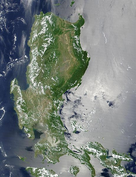
Barakas:Northern Philippines (Luzon).jpg

Takaran tilikan ngini: 461 × 599 piksal. Risulusi lain: 184 × 240 piksal | 369 × 480 piksal | 591 × 768 piksal | 788 × 1.024 piksal | 2.000 × 2.600 piksal.
Ukuran asli (2.000 × 2.600 piksel, ukuran barakas: 738 KB, tipe MIME: image/jpeg)
Riwayat barakas
Klik pada tanggal/waktu gasan manjanaki barakas ngini wayah itu.
| Tanggal/Waktu | Miniatur | Matra | Pamakai | Ulasan | |
|---|---|---|---|---|---|
| wayahini | 26 Uktubir 2005 05.52 |  | 2.000 × 2.600 (738 KB) | Brian0918 | * Credit Jacques Descloitres, MODIS Land Rapid Response Team, NASA/GSFC This MODIS true-color image of the northern Philippines shows the island of Luzon and the Cagayan River running in the plains between the Sierra Madre mountain rang |
Tautan barakas
Tungkaran nangini mamakai barakas ngini:
Pamakaian barakas global
Wiki lain nangini mamakai barakas ngini:
- Pamakaian pada af.wikipedia.org
- Pamakaian pada ar.wikipedia.org
- Pamakaian pada arz.wikipedia.org
- Pamakaian pada ast.wikipedia.org
- Pamakaian pada ba.wikipedia.org
- Pamakaian pada be-tarask.wikipedia.org
- Pamakaian pada be.wikipedia.org
- Pamakaian pada bg.wikipedia.org
- Pamakaian pada bo.wikipedia.org
- Pamakaian pada ca.wikipedia.org
- Pamakaian pada cy.wikipedia.org
- Pamakaian pada de.wikipedia.org
- Pamakaian pada el.wikipedia.org
- Pamakaian pada en.wikipedia.org
- Pamakaian pada eo.wikipedia.org
- Pamakaian pada es.wikipedia.org
- Pamakaian pada et.wikipedia.org
- Pamakaian pada eu.wikipedia.org
- Pamakaian pada fa.wikipedia.org
- Pamakaian pada fi.wiktionary.org
- Pamakaian pada fr.wikipedia.org
- Pamakaian pada fr.wikivoyage.org
- Pamakaian pada ga.wikipedia.org
- Pamakaian pada he.wikipedia.org
- Pamakaian pada hu.wikipedia.org
- Pamakaian pada hy.wikipedia.org
- Pamakaian pada ia.wikipedia.org
- Pamakaian pada id.wikipedia.org
- Pamakaian pada id.wiktionary.org
- Pamakaian pada incubator.wikimedia.org
- Pamakaian pada jv.wikipedia.org
- Pamakaian pada ka.wikipedia.org
- Pamakaian pada ky.wikipedia.org
- Pamakaian pada lv.wikipedia.org
- Pamakaian pada ms.wikipedia.org
- Pamakaian pada nn.wikipedia.org
- Pamakaian pada os.wikipedia.org
- Pamakaian pada pl.wikipedia.org
Lihat labih banyak pamakaian glubal matan barakas ngini.

